GeoAI · Earth observation · Health intelligence
Seeing health risk from orbit to ground.
GeoVita Intelligence fuses satellite, aerial and UAV imagery with GIS and artificial intelligence to locate the environmental conditions behind vector-borne disease and other biological hazards — so organisations can act where it matters, not everywhere at once.
- Grid cells modelled
- 1.46 M
- Years of data
- 2000–2024
- Spatial CV correlation
- r 0.993
Live layer
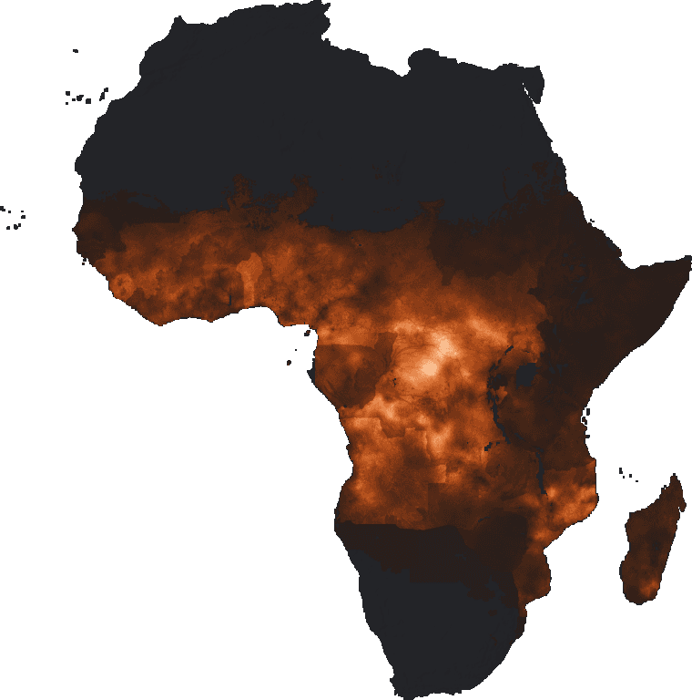
Malaria endemicity (PfPR₂–₁₀), Africa 2024
Sentinel-1 SAR, Sentinel-2 MSI, Landsat 8/9, MODIS, NASA GLDAS, ERA5-Land, SRTM DEM, Aerial stereo, UAV multispectral, Field & entomology
The challenge
Environmental data is abundant. Targeted decisions are not.
Satellites observe the planet every day, yet vector-control teams and health authorities still survey vast areas blindly. The gap is not data — it is turning fragmented signals into where-and-when answers.
Fragmented signals
Satellite, climate, terrain and field records sit in different formats, scales and silos, rarely combined in one operational view.
Costly blanket coverage
Without priority maps, inspection and spraying programmes spread limited resources evenly instead of where risk concentrates.
Hidden, temporary habitats
Small ponds and depressions that breed mosquitoes appear after rain and vanish — invisible to coarse imagery and routine surveys.
How it works
One workflow, from continental screening to a single pond.
Each scale narrows the search for the next, cutting the cost and time of field surveys while keeping every decision geographically explicit.
- 01
Regional satellite screening
Wide-area, repeated observation of vegetation, water, moisture and temperature.
~5 km · continent
- 02
AI / GeoAI risk modelling
Machine and deep learning link environmental history to vector and disease evidence.
Spatiotemporal
- 03
Priority-area identification
Explainable risk surfaces with uncertainty highlight where to look first.
Ranked hotspots
- 04
High-resolution UAV / aerial assessment
Drones and aerial stereo reveal habitats, depressions and land cover in detail.
~10 cm · site
- 05
Targeted intervention & monitoring
Teams inspect, treat and record outcomes, feeding a continuous learning loop.
Field action
What we map
Intelligence for the places where environment shapes health.
Our first focus is vector-borne disease — and the same multi-scale engine extends to other biological hazards influenced by habitat and climate.
Vector-borne disease surveillance
Map environmental conditions and habitats associated with mosquitoes and other disease vectors.
Targeted vector control
Risk maps that help spraying and control teams prioritise sites for inspection and intervention.
Public-health decision support
Spatial intelligence for surveillance planning and resource allocation by health authorities.
Venomous-species habitats
Assess habitats linked to medically significant snakes and scorpions to support prevention.
Tourism & travel risk
Location-specific environmental risk information for operators working in exposed regions.
Research & environmental monitoring
AI-assisted spatial analysis and high-resolution mapping for universities, NGOs and agencies.
Live demo
Sixteen years of malaria endemicity, forecast across Africa.
Spin the globe, scrub the timeline and compare what was observed with what our ConvLSTM2D model predicted — including an untouched 2022–2024 forecast test.
- grid cells at ~5 km
- 1,457,085
- environmental predictors
- 10
- models & benchmarks compared
- 8
- spatial-CV correlation (r)
- 0.993
EPSG:3857 · 5 km
Scientific foundation
Built on peer-reviewed research, not promises.
The founding team has published on remote-sensing habitat detection, malaria and leishmaniasis risk mapping, vector abundance and spatiotemporal deep learning.
12 / 14
long-lasting larval habitats matched in the field using 10 cm aerial imagery
94.3 %
overall accuracy of the land-use and soil-type classification
250 km
spatial blocks used to prove models transfer to unseen regions
Responsible by design
Trustworthy intelligence for high-stakes decisions.
Validated honestly
Spatially separated and untouched temporal tests, always against strong naïve benchmarks.
Explainable
Driver attribution and uncertainty shown alongside every risk surface.
Human in command
Outputs support, never replace, field surveillance and expert judgement.
Privacy first
Environmental features separated from sensitive data; GDPR and EU AI Act aware.
Where we work
European roots, global reach.
Spain and Finland are being considered as European bases. Our solutions target regions where environmental and health risks demand cost-effective, geographically targeted monitoring — with a particular focus on Africa and the Middle East.
Europe
R&D and company base
Spain · Finland (under consideration)
Africa
Pilots & validation
Vector-borne disease and habitat risk
Middle East
Research partnerships
Water, climate and vector ecology
Partnerships
Let's validate GeoVita where it matters most.
We are seeking non-binding expressions of interest, letters of support and pilot partners — especially ministries of health, vector-control organisations and research institutions across Africa.